

“It is not the mountain we conquer, but ourselves”
– Edmund Hilary
“Of all the paths you take in life, make sure a few of them are dirt”
– Jon Muir
Imagine a place surrounded by a 360-degree view of mountain ranges so tall and rugged they seem to jut right into the heavens, sometimes shrouded by fluffy clouds of cotton candy, illuminating the sky in bright oranges and pinks during sunset. When the sun rises, the crisp air makes the hairs on your skin stand ever so slightly, a nice reprieve from the normal August mid-day heat. Soft purples paint the dawn sky as the moon sets in the distance and the sun slowly starts to wake up the town. Imagine deep valleys in the heart of the mountains built in Bavarian architecture, charming and filled with wild goats and sheep roaming freely. As you gaze up into the clear blue sky, you are delighted with paragliders swooping through the valleys and soaring above peaks like majestic eagles. This place exists, and it is called the Dolomites in Northern Italy, a climbers and hikers paradise in the Italian Alps. Dolomiti Bellunesi National Park was added to the UNESCO world heritage list in 2009 for its geological uniqueness.
Where to Stay in the Dolomites
We stayed a total of three nights in the area. Belluno is the closest main town to the Dolomites, just a 30-minute drive from one of the many main entrances to the national park. In the town of Belluno, you can stock up on sundries, groceries at Super W (their local supermarket), or have a meal at one of their several pizzerias and other casual restaurants. The nearby town of Feltre is also a good home base if you have a rental car.
Rifugios
Rifugios (refuge) are usually family-owned accommodation with rooms for sleeping and a restaurant/bar that typically serves local, home made food for hikers who are passing through the mountains on long journeys, such as the one from Munich, Germany to Venice, Italy, a 30-day hiking trek along the E5 trail. Rifugios are usually located away from cities in remote locations. They are open to the public, so both locals and transient travelers visit, and no prior reservations are required; you simply show up and come as you are.
We book most of our accommodation on our long-term travel adventures through Booking.com. This is where we found Rifugio Col Di Roanza, which, unbeknownst to us, turned out to be a rifugio! Here’s a photo of the beautiful property.


We enjoyed this beautiful mountain backdrop view several times during our meals.


The property is quite large and contains two beautiful wild horses and three donkeys, who loved cuddles and were calm and tame. They crave human attention and love getting their pets!

We enjoyed delicious vegetarian meals during our stay. Everything was from this region of Italy, made from the hands of a woman who is passionate about food, farms, and healthy eating.


 copy 2")
 copy")
Where To Hike In The Dolomites
I recommend driving around the national park one day and enjoying the pristine mountain views that make you feel as though you are in Switzerland. The access road through the national park is accessible via the town of Belluno. We hiked a total of three days and felt we could have spent an entire week here.

You can see the scale of the mountains based on the tiny village that lies below.


Houses are built in Bavarian style because it is so close to the border of Austria.


Can you imagine living in a place like this, waking up to see these mountains every day?


Bavarian style architecture.
HIKING IN THE DOLOMITES
We did two long day hikes which I will explain in detail below.
1) Rifugio Alpini 7°
Length: 14 kilometers (8.7 miles) round trip
Hiking Level: difficult
Elevation Gain: 1,200 meters (3,600 feet)
Time: Approximately 9 hours (7.5 of hiking, 1.5 of rest at the rifugio)
This hike actually began from the backyard of our own rifugio, Col di Roanza, and ended up at another rifugio way up high in the mountains. The hike took us 9 hours, including a 20-minute dip in a cold swimming hole with turquoise water (a much-needed refreshment from the hot mountain sun), and a 1.5-hour stop at the rifugio once we reached the top. Thank goodness our reward was the rifugio because it was not an easy hike in the August heat.
The photo below is what you look up at before you start the hike. (The hike doesn’t bring you to the top of those peaks, but there is a way that you can ascend the summit, however, climbing gear is necessary.) If you have your own gear with you (including a helmet), you can stay overnight at Alpini Rifugio 7° and continue on to summit the peaks the following day.

From Col di Roanza Rifugio, start walking down the hill. In less than five minutes you will see a trail on the right side of the road. This is where the hike begins. About 20 minutes into the hike, you will see a bench, which we titled “Bench at the End of the World”.

Feeling quite small in the scheme of the world.

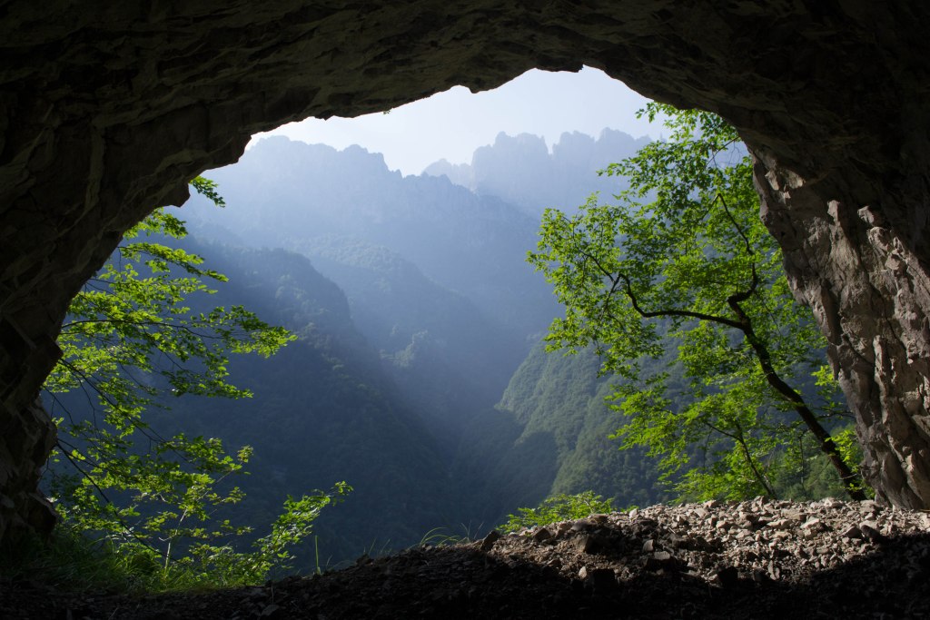
Stunning lighting sifting through the mountains in layers.

In absolute awe at such a beautiful place in the world.
Very shortly after the bench, you will reach a tunnel that is nearly 1.6 kilometers (one mile) long, so bring a headlamp, flashlight or phone with bright illumination.


The light coming through the tunnel breaks made for some phenomenal silhouette photos.


We crossed several streams and continued to follow the river until we ascended the mountain. (The start of the hike is relatively flat and very easy and calm through a covered forest.)


There are endless options for a refreshing dip in hundreds of intimate natural pools, carved out by years of water cascading down the mountain, shaping natural water slides and turquoise swimming holes.


Starting the final ascent to the rifugio…feeling quite ready for a break from the ascent. An ice cold water and espresso was very enticing at this point.


We passed a snake!!! Or so we thought…

But something seemed a bit off…the snake looked a bit too shiny and too still…
Later when I downloaded photos to my computer to edit them, I zoomed way in and noticed a divot in its head! Some prankster placed a fake snake on the rock! Perhaps it is to warn people that there are snakes in this area and to be cautious. It worked for me!

After nearly four hours of hiking, feeling quite tired and hot, we finally saw the rifugio in sight. I’ve never been so happy to know that food and rest were within reach!

We spent over an hour outside in the shade under umbrellas overlooking the entire valley below and jagged peaks above. This rifugio is owned and operated by a young family. We ordered pasta, local sausages with polenta and tomato sauce, ice cold water, espresso, a Ritter Sport chocolate bar and 2 tiramisu, then promptly took a nap after major food coma. Refueling is necessary after a demanding hike like this! You’ll need that energy to get back down!


The hut to the left is where the owners operate their teleferico, which is the only way to deliver goods to and from town, as there is no access road to get to this rifugio. It is truly remote and secluded. The teleferico takes approximately half an hour to go across the valley and up and over the mountain to the other side, where there is another station with an access road to Belluno town. The workers spend three months working here during summer (all other months are too cold and snowy to be open). The only way for them to get up and down the mountain is to hike the four hours up or down (you’d better not forget anything you need once you leave!)
2) Monte Serva
Length: 6 kilometers (3.7 miles) round trip
Hiking Level: moderate
Elevation Gain: 1,100 meters (3,300 feet)
Total Elevation at the Top: 2,133 meters (nearly 7,000 feet)
Time: Approximately 6 hours round trip
On our third and last day in Dolomiti Bellunesi National Park, we hiked Monte Serva, since the trailhead was very close to our rifugio. Since sunrise in August is 6:00 AM, we woke up at 5:00 AM to get an early start at 5:30 AM. The views and the fact that we only saw a few other people on the entire hike, made it completely worth it!
How to Get There
From Col di Roanza rifugio, drive up the hill until the road ends. Be very cautious, as the road is extremely narrow with no side rails, and traffic is two ways. Sometimes we had to do a two-point turn just to make a tight hairpin curve because the road was so narrow. After about five minutes of driving, the paved road will end and a gravel road will begin (pictured below.)

Park to the side of the road (you may see other cars, unless you go extremely early.) You’ll see this sign:


This is the beginning of the trail. The entire hike is directly uphill on a steep slope and never flattens out, so be prepared for your thighs and calves to burn!
Little did we know that later that afternoon it would torrential downpour in a dangerously strong storm that lasted a full hour. Good thing we weren’t caught in it! The air is crisp and cool so early in the morning, and I love that time of day because the world has not yet woken up and it feels as though you have the entire earth to yourselves.


A little more than halfway up the route, you will come across a private home with four aggressive dogs on chains who will bark at you like crazy. If their owner is not home, they are extremely ferocious so do not pet them! If the owner is home, they will be a little more calm, but you still should not pet them. They are guard dogs in charge of herding all the goats and sheep that roam the mountain freely. The owner’s front yard is open to hiker passerby and you are welcome to come in the gate and rest your feet on the benches provided (no need to knock, just let yourself into the gate to sit in the outdoor section pictured below.) This is an excellent place to have a snack before completing the ascent. You can see the sign in the photo below that says “attenti cane” (beware of dogs).

From this house, you are really close in distance, but not necessarily in length because the final stretch is even steeper. Once you get to the goats, you know you’re at the top.


Once you finally reach the top (2,333 meters / nearly 7,000 feet), it truly feels as though you are on top of the world. All struggling and feelings of wanting to collapse quickly fade as you are greeted with these views:


Some stunning panoramas (that’s me doing a leapfrog over the summit post on the far right of the below photo):


I hope you found this post to be helpful in planning your trip to the Dolomites!